20 Jul Flooding scenarios for 2100 for Mykonos, Delos and Andros Islands (Cyclades, Greece)
Points of Support: small grants – big ideas, 6th cycle
The research project is conducted by the Society for the Study of Ancient Coastlines – AKTES. It started on 1 October 2023 and was completed on 31 March 2024. The action is implemented with a donation from Athina I. Martinou Foundation, in the framework of “Points of Support”, a co-funded programme by John S. Latsis Public Benefit Foundation, TIMA Charitable Foundation, Captain Vassilis and Carmen Constantakopoulos Foundation, A. G. Leventis Foundation, AC Laskaridis Charitable Foundation, Costas M. Lemos Foundation, Social and Cultural Affairs Welfare Foundation (KIKPE), The Hellenic Initiative Canada, Athina I. Martinou Foundation, and Bodossaki Foundation. The Programme aims to support original small-scale actions with maximum social impact for the benefit of vulnerable social groups. The full list of organizations selected for funding in the context of the 6th cycle of “Points of Suuport” by thematic section, here: https://tinyurl.com/2j2b66xj.
The aim of the AKTES project is to develop the flooding scenarios by 2050 and 2100 due to sea level rise with a pilot application on the islands of Andros, Mykonos and Delos (Cyclades, Greece). Within the project’s framework, accurate geospatial data is collected in selected coastal lowlands, intensively economically and touristically exploited. More particular, the pilot areas are: the port of Gavrio and the bay of Nimporio of Chora in Andros, the bays of Ornos and Korfos in Mykonos, and the sea front of ancient Delos. Drone digital photogrammetry is applied to produce very high-resolution digital surface models (DSMs) and very detailed and crisp orthomosaics for the survey areas. On these, the sea level rise projections up to 2100 are implemented, based on different climate change scenarios of projected socioeconomic global changes (SSPs) on a regional scale, as defined in the 6th Assessment Report of the Intergovernmental Panel on Climate Change (AR6, IPCC). At the same time, the local subsidence rate of the central Aegean is taken into account, according to time series data sets provided by the installed GPS stations. In that way detailed maps of the vulnerable areas are produced, illustrating the areas that will be subject to gradual inundation by the sea up to 2100. The inferred predictions have a strong social impact on coastal communities and are decisive in the planning of coastal infrastructure and imposition of civil protection measures.
The action was completed by disseminating the project’s outcome to the local communities of Mykonos and Andros through social scientific events that will be co-organized by AKTES with the Municipality of Andros and the KDEPPAM of Mykonos.
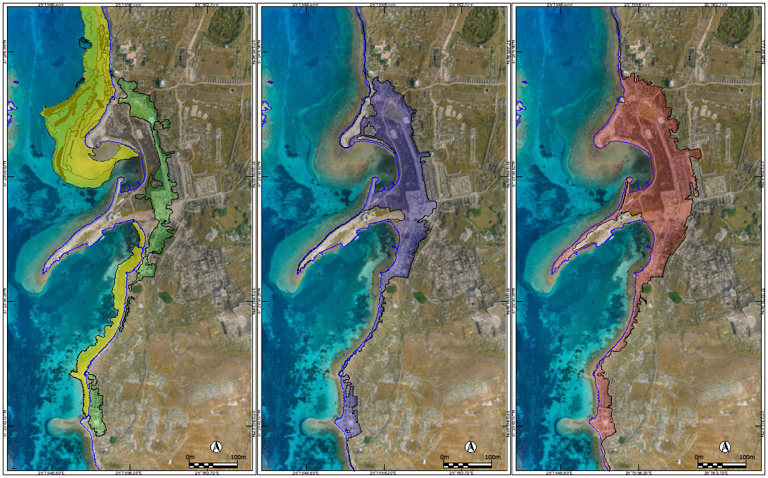
The image shows the coast of Delos as it now stands and the sea-level rise predictions (AKTES research project). On the left, the today submerged areas are indicated by yellow colour and by green colour the marshy areas on land, permanently or periodically flooded due to sea level rise. In the middle, the areas that will be gradually flooded by 2050 are indicated by blue colour and on the right the areas that will gradually be covered by the sea until 2100 by red colour. The orthomosaic used in this illustration comes from the Web SIG de Délos, École française d’Athènes (https://www.efa.gr/web-sig-de-delos/, accessed 10.11.2023)